|
|
|
|
| Pro 1
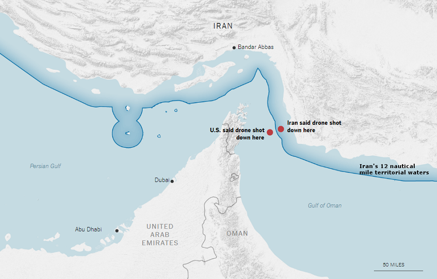
Lt. Gen. Joseph Guastella, Commander of US Air Forces Central Command, said on June 20, 2019 that the US surveillance drone “was operating at high-altitude approximately 34 kilometers [21.1 miles] from the nearest point of land on the Iranian coast.”
According to Guastella, the drone was flying over the Gulf of Oman and the Strait of Hormuz and fell into international waters after being shot down. He also said, “This attack is an attempt to disrupt our ability to monitor the area following recent threats to international shipping and free flow of commerce. Iranian reports that this aircraft was shot down over Iran are categorically false.” |
|
Con 1
Mohammad Javad Zarif, Iran’s foreign minister, wrote on Twitter on June 20, 2019 that, “At 00:14 US drone took off from UAE in stealth mode & violated Iranian airspace. It was targeted at 04:05 at the coordinates (25°59’43″N 57°02’25″E) near Kouh-e Mobarak. We’ve retrieved sections of the US military drone in OUR territorial waters where it was shot down.”
The coordinates provided by Zarif place the US drone about eight miles off the coast of Iran, well within the 12 nautical miles that mark Iran’s territory. |
| |
|
|
| Pro 2The Pentagon said US surveillance drone was on a reconnaissance mission following attacks on oil tankers in the region and released a map showing that it was shot down over international waters. |
|
Con 2Iran asserts that shooting down what it calls a US spy drone was within its right of “self-defence if an armed attack occurs,” as stated in Article 51 of the UN Charter. |
| |
|
|
| |
|
|
| Pro 3The White House has confirmed that the drone was flying in international airspace. Secretary of State Mike Pompeo said in a statement that “the United States has shown beyond any doubt that Iran shot down a U.S. unmanned aircraft in international airspace. Foreign Minister Zarif’s hand-drawn map disputing this fact is not credible. This attack marks the second time Iran targeted an American unmanned aircraft in recent weeks.”
President Trump also spoke about the drone’s location, saying, “This drone was in international waters, clearly. We have it all documented. It’s documented scientifically, not just words.” |
|
Con 3The Islamic Revolution Guards Corps (IRGC) said that the US drone took off at 00:14 local time from a US military base south of the Persian Gulf and turned off all identification to operate in stealth mode, then entered Iranian airspace on its return journey.
The IRGC stated, “The drone started collecting intel in a spying operation when it was returning towards the Western parts of the region near the Strait of Hormuz and it violated the airspace over the Islamic Republic of Iran’s territory. The IRGC Aerospace Force’s air defense system targeted and destroyed the hostile aircraft which had entered Iran’s territorial airspace at 04:05 am.” |
| Discussion Questions – Things to Think About |
| 1. Is it possible that either the United States or Iran gave the GPS coordinates in good faith but somehow made a mistake about the actual location of the US drone? Explain your thoughts.
2. What other motivations or specific reasons could either country have for their statements on the drone’s location aside from lying or misleading? |
Footnotes:
- Natasha Turak, “Iran Shoots down American Drone in International Airspace in ‘Unprovoked Attack,’ US Says,” cnbc.com, June 20, 2019
- BBC News, “Strait of Hormuz: US Confirms Drone Shot down by Iran,” bbc.com, June 20, 2019
- Jackie Northam, “U.S. and Iran Disagree over whether Drone Was Shot down over Iranian Territory,” npr.org, June 20, 2019
- World Ocean Review,” WOR 3 Marine Resources – Opportunities and Risks,” worldoceanreview.com, 2014
- United Nations Treaty Collection, “United Nations Convention on the Law of the Sea,” un.org, Mar. 7, 2019
- Ian Beck, “The U.S. and the UN Convention on the Law of the Sea,” intpolicydigest.org, Nov. 22, 2018
- Patrick Goodenough, “As US, Iran Tussle over Location of Downed Drone, Trump Says ‘This Country Will Not Stand for It,'” cnsnews.com, June 20, 2019
- US National Oceanic and Atmospheric Administration, “U.S. Maritime Limits & Boundaries,” nauticalcharts.noaa.gov (accessed July 2, 2019)
- Mark J. Valencia, “Overreaction in the Strait of Hormuz,” thediplomat.com, May 11, 2015
- United Nations, “United Nations Convention on the Law of the Sea: Part II Territorial Sea and Contiguous Zone,” un.org (accessed July 2, 2019)
- Diana Stancy Correll, “Pentagon Issues Map Depicting US Drone Shot over International Waters,” militarytimes.com, June 20, 2019
- Tom O’Connor, “Iran Tries to Counter U.S. Military Claims by Releasing Drawing of What It Says Happened to Drone,” newsweek.com, June 20, 2019
- Tehran Times, “Iran Files Complaint against U.S. over Violating Its Airspace,” tehrantimes.com, June 29, 2019
- Jim Garamone, “Iran Shoots Down U.S. Global Hawk Operating in International Airspace,” defense.gov, June 20, 2019
- Talia Kaplan, “Pentagon Releases Map Disputing Claim US Drone Violated Iranian Airspace; Iran’s Version Is Very Different,” foxnews.com, June 20, 2019
- United Nations, “Chapter VII — Action with Respect to Threats to the Peace, Breaches of the Peace, and Acts of Aggression,” Charter of the United Nations (accessed July 2, 2019)
- Michael R. Pompeo, “Statement on Iranian Disinformation,” state.gov, June 22, 2019
- Michael D. Shear, Eric Schmitt, Michael Crowley and Maggie Haberman, “Strikes on Iran Approved by Trump, Then Abruptly Pulled Back,” nytimes.com, June 20, 2019
- Fars News Agency, “Iran: US Drone Warned Several Times,” en.farsnews.com, June 21, 2019
|
|